
PROJECT OBJECTIVES:
Aerometrex’s LiDAR data is helping landowners understand how they can better manage their land, understanding and appreciating the nuances of the landscape. While the data sometimes validated their knowledge of the land, in other instances, it also highlighted where they may be wrong and need to adjust their land management strategies.
The key to this kind of LiDAR data is its ability to help them look at sizeable information across land properties, because various challenges, for example, gully erosion, have trigger points beyond your immediate visible line of sight if you’re on the ground. LiDAR helps see the bigger picture and a refined understanding of the nuances in the landscape. Sharing their experience at a site in Melaleuca, a consultant was able to accurately pinpoint sinkholes using the LiDAR survey, saving a lot of time and effort, and avoiding the potential of missing some of them.
Whetstone/Salmon Gums
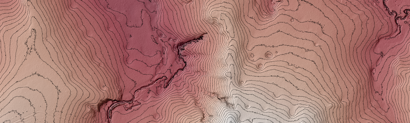
Digital Terrain Model (DTM) with Contours of a project site in Salmon Gums
Another major component has been understanding vegetation, for which the project incorporated Aerometrex’s Type 2 LiDAR classification. This generated data that could help understand existing native vegetation vs remnant, recovered, or cleared vegetation. This project has thus helped showcase due diligence on the landowners’ part and highlight good stewardship and their willingness to do the right thing. Accurate data can also help compare information about native vegetation with government data.
One of the other objectives of the survey was to understand the slope more accurately and understand the approval criteria for land development. This data can help evaluate the risks of clearing and showcase to regulatory authorities that landowners have done the necessary due diligence. It provides a dataset to add to the existing satellite-based slope calculations from the NT government and refine information - it helps create greater transparency.
PROJECT BACKGROUND:
In 2020-21, LiDAR was captured for a small area around Tipperary Station, as part of a Landcare Grant, to understand and address issues pertaining to erosion mitigation and control. Some of the land on this pastoral lease station had recently been approved for non-pastoral use to grow crops and LiDAR was seen as an opportunity to help improve land and water management and cropping outcomes. This pilot was pivotal in showcasing the potential of LiDAR and the amount of detail about the land that could be obtained – not just for agricultural purposes, but for appreciation of the landscape and the environment. A survey among NT Farmers’ members conducted in Nov 2021 showed interest in the concept and eagerness to capture more LiDAR – that was the seed for this Aerometrex project with NT Farmers. Post discussions with numerous stakeholders and landowners across NT, by April-May 2022, there was a significant area of interest (220,000 hectares) earmarked for a larger LiDAR capture.
Simone Cameron, LiDAR Champion
THE DIVERSE STAKEHOLDER GROUP:
The area of interest for this LiDAR survey was spread across 23 locations in Northern Territory and the project was funded by landowners directly - with in-kind support from not-for-profit organisation, NT Farmers. These land parcels were under the control of over 15 stakeholders, from individual/family landowners to large corporate entities. This meant that while some stakeholders had small areas of 500-600 hectares, some others were over 45,000. One of the objectives of this project was “inclusiveness” irrespective of property size, and catering to very diverse requirements.
The project has been a great example of coordination to navigate and negotiate requirements among all these varying entities and the Regional Director at NT Farmers, Simone Cameron, has been crucial to the process. Her involvement has helped tailor the survey to maximise benefits for all the landowners addressing their priorities.
STAKEHOLDER ENGAGEMENT:
Critical to this project has been the education of landowners, to ensure they can maximise the return from the data being captured. Engagement strategies such as webinars have helped members engage with Aerometrex directly and understand the value of the data captured and its multiple applications – not just land development or planning parcels of land for clearing. Additionally, NT Farmers is working with partners such as Graeme Owen from VPS Land Assessment and Planning, to build resource materials linked to data usage and software applications such as QGIS or helping landowners directly to integrate data into platforms such as Avenza Maps.
NT Farmers served as a trusted facilitator – one that landowners could reach out to and share requirements, as well as address queries, in complete confidence. They could also support engagement with other partners within the AgTech space to further the return from the LiDAR data – the likes of Agronomeye, and others. While corporates were easier to bring on board due to their prior experience with LiDAR, relationships and advocates among the family-owned landholders were key to bringing the other end of the spectrum on board for the project – the likes of Tony Hayne from Douglas Station.
THE NEXT STEPS:
NT Farmers hopes to drive stories and case studies showcasing good land stewardship among the community. In an ideal world, they’d love to see the whole of NT being captured with LiDAR to support the various objectives listed above. Another key next step is to build awareness and comfort among the traditional owners because over 50% of land in the NT is owned by Schedule 1 Aboriginal Lands Trust. To build trust amongst that stakeholder group, there need to be concrete examples of success, of the data in action, on the ground. They want to build synergy and bring modern technology to work with the First Nations principles and blend the two. Having classified LiDAR data at the chosen specifications of Level 2 has also future-proofed it and made it useful for other advanced applications such as complex habitat mapping, natural capital assessment or carbon offsets.
ABOUT NT FARMERS:
The Northern Territory Farmers Association (NT Farmers) represents and advocates for the plant-based industries of the NT. As a peak industry body, NT Farmers promotes agricultural development in the Northern Territory and directly assists growers with a comprehensive range of support services. The association is at the forefront of driving agricultural policy and investment in northern Australia. Work undertaken by the association has been instrumental in growing the value of the plant-based agricultural sector in the NT. Direct support activities to the industry include biosecurity awareness, horticultural extension and advice, the promotion of the industry to job seekers, agricultural education activities in classrooms and industry field days. NT Farmers is a not-for-profit association that receives project funding from the public and private sectors.