Our world’s first bushfire fuel load mapping system has become more powerful with three new data sets that will make it more effective in bushfire preparation and response, and more scalable Australia-wide.
From a single LiDAR capture anywhere in Australia, we can now:
Our data will directly impact fire management from preparation and prevention activities to real-time response during bushfire events.
This page explains our capture method, our new data outputs, and how we can better help the planning, prevention, and direct interventions in bushfires.
We use fixed-wing planes with LiDAR (light detection and ranging) sensors to capture up to 150km2 per day. It’s a cost-effective and scalable method thanks to the fixed-wing platform’s operational range and movement speed. No other aerial platform comes close to capturing as quickly and with such detail. We can capture in minutes, as part of a whole-day capture, with fixed-wing platforms what a drone will take a day to replicate.
The LiDAR sensors measure the time and intensity that laser pulses reflect off surfaces. Each laser pulse reflection becomes part of a point cloud that we classify into buildings, trees, water features, and other structures. We use the LiDAR data to assess foliage structure and density from the canopy down to 25-50cm above ground level.
Those captures are the basis of our fuel load data service. Every element of the service described below comes from the same data capture.
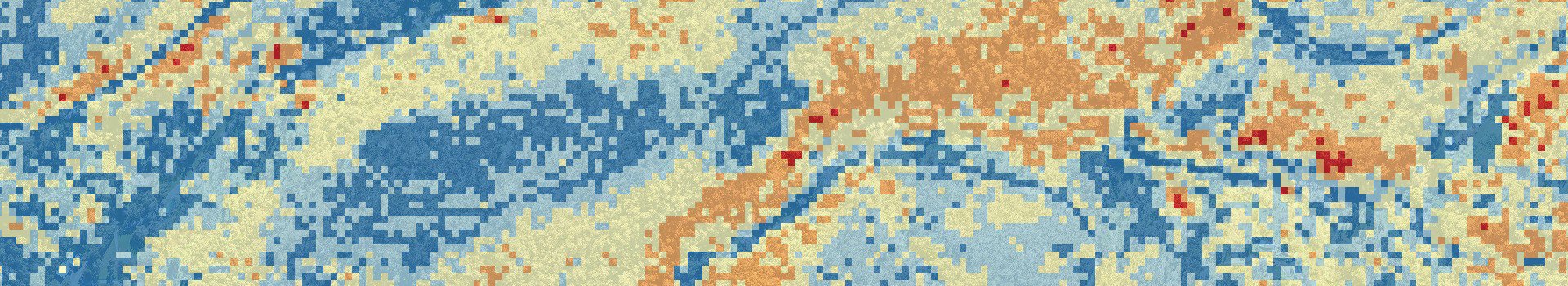
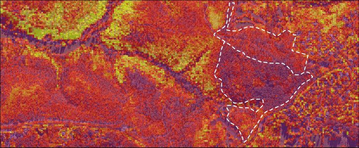
Our fuel load maps now have data on fuel load tonnes per hectare calculation (TPHa).
We responded to feedback from fire services who wanted TPHa metrics by making a calculation system that can be adapted to anywhere around Australia. Fuel load TPHa is essential data when assessing potential bushfire risk and response to active fires, and no previous system can match the accuracy of what we’ve developed.
The TPHa fuel load calculation uses our captured LiDAR data and applies foliage weight results.
Fire services around Australia regularly run measurement tests by taking samples of plant matter, dehydrating them, and weighing the dry biomass as a baseline measurement to calculate the TPHa. We use extrapolated results from those tests to predict how areas will burn based on their specific foliage types and density. Dry weight biomass tests are repeated over time to improve the data, and our calculations will improve in tandem.
Our calculation algorithm applies to any foliage flammability data set. Our test case in South Australia’s Belair National Park has used the eucalyptus woodland and forest data common to the Adelaide Hills. All we need is the test results from other foliage types to make the TPHa calculation anywhere in Australia.

Tonnes per hectare
We calibrate TPHa data outputs to account for each end-member vegetation type.
Additional captures in new end-member vegetation types are carefully planned to include field sites that represent the full spectrum of bushfire fuel hazards within the area. This will provide a robust calibration dataset covering the full range from minimum to maximum fuel loads associated with each vegetation type.
Total fuel load and TPHa data are made significantly more valuable by our stratified fuel load measurement. The LiDAR capture’s ability to measure from tree canopy to the ground is data that’s never been available on this scale before and can change bushfire prevention and response. We call it “vertical connectivity” and it’s a powerful indicator of potential bushfire severity.
Vertical connectivity refers to the fuel load between the ground and canopy. Bushfires move faster and are more difficult to contain once they’ve reached the tree canopies. Vertical connectivity becomes invaluable data for predicting the potential for surface fires to climb ladder fuel and ignite the upper canopy.

Areas of high fuel load density and high vertical connectivity represent the most extreme fire danger. Fire services can use this data to better plan prescribed burns and bushfire response by using vertical connectivity foliage data.
Our LiDAR system can see foliage that's invisible below the canopy to give the most accurate and timely fuel load data in these stratified zones:

The third data suite we’ve added is property-specific assessments that analyse fuel loads, bushfire attack level, and significant water body identification.
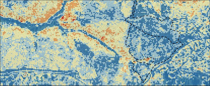
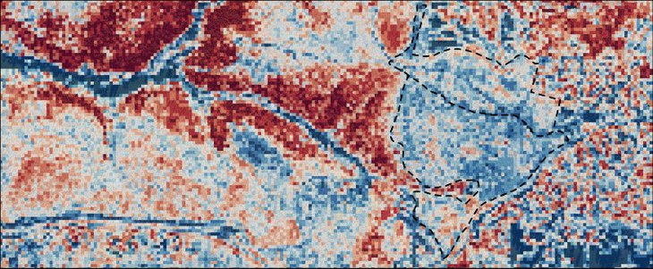
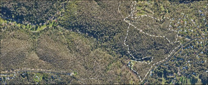
Individual fuel load assessments of any property in a captured area are done by applying their boundary data (cadastral) and calculating all data within it. Assessments are rapid and easily scaled from individual properties to businesses, commercial land, to hundreds of square kilometres.
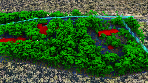
Property-level classified LiDAR with trees and buildings.
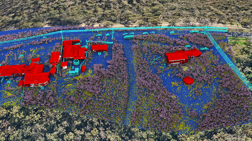
LiDAR data with the tree canopies hidden to show lower foliage.
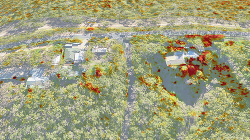
Fuel load density view - red indicates high fuel load.
The images above show how we can analyse specific properties and isolate the exact fuel loads on them.
Our system automatically identifies significant water bodies and assesses their potential utility during bushfires.
The system recognises pools, dams, and other water features and verifies their distance from tree canopies. That data tells emergency services exactly where fire-fighting platforms like helicopters or trucks can find usable water sources. Canopy separation is vital for helicopters that need to take on the water safely.
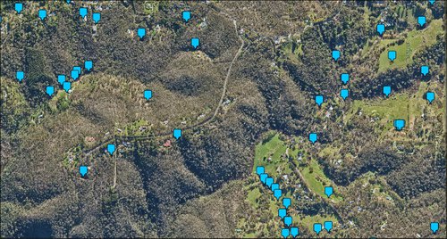
We identify water sources that have a surface area of 10m2 or greater.
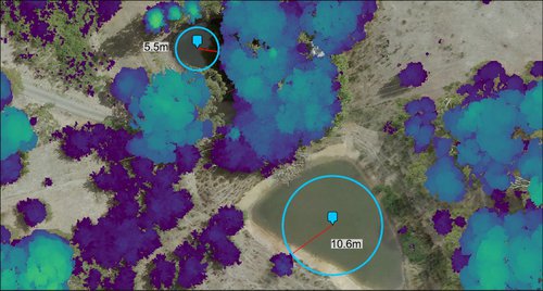
We then validate tree canopy separation.
Our accurate bushfire fuel load data makes the standardised Bushfire Attack Level (BAL) classifications faster and more consistent.
BAL ratings include Fire Danger Index, the slope of the land around the structure, and vegetation surrounding a property. Our LiDAR captures include Digital Terrain Maps (DTM) that show land slopes and our bushfire fuel load measurements are a complete assessment of vegetation around a property.
We can make BAL assessments faster, and based on more accurate data than any previous method. Subsequent captures can update BAL classifications over time.
Our bushfire fuel load mapping service is ready to improve Australia’s capability to prepare for and respond to bushfires. No other fuel load assessment system captures at this scale, accuracy, or depth of data in such a short time frame. The service is adaptable anywhere we can collaborate with fire services to get foliage burn data.

Get the most accurate data to empower emergency planning and response.
We're ready to help prepare for, and fight bushfires with the most accurate information available.